One of the biggest draws of living in Anaheim Hills is having world-class hiking right in your backyard. While most people associate Anaheim with theme parks, residents here know the real magic happens in the rolling hills, oak-shaded canyons, and wildflower-covered ridgelines that surround our community.
With over 1,500 acres of preserved open space and direct trail connections stretching all the way to the Pacific Ocean, Anaheim Hills offers something for every type of outdoor enthusiast. Whether you're looking for a quick morning walk with the dog, a challenging ridge hike with panoramic views, or a family-friendly nature outing, there's a trail for you.
Here's your local guide to the best outdoor spots in Anaheim Hills.
Oak Canyon Nature Center
Address: 6700 E Walnut Canyon Rd, Anaheim, CA 92807
Oak Canyon Nature Center is the crown jewel of Anaheim Hills hiking. This 58-acre natural park sits tucked into the hills just past Anaheim Hills Golf Course, offering a true escape from suburban life minutes from home.
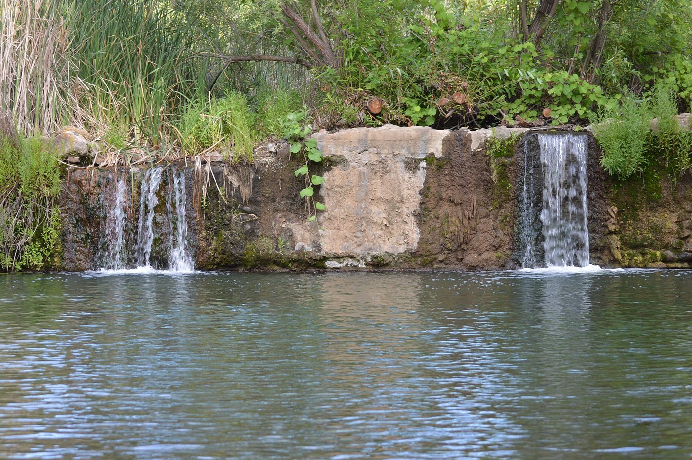
The park features four miles of hiking trails through one of the few remaining areas of native oak woodland and coastal sage scrub in the region. A year-round stream meanders through three adjoining canyons, creating a peaceful backdrop that feels worlds away from the city.
What makes it special:
- Stream Trail offers shaded walking along the creek with wooden bridges and small waterfalls
- Roadrunner Ridge provides elevated views of Anaheim Hills with a moderate climb
- The John J. Collier Interpretive Center houses live animal exhibits and natural history displays
- Connected to Walnut Canyon Reservoir Trail and the broader regional trail system
Details
Feature | Information |
|---|---|
Trail Distance | 4 miles of trails |
Difficulty | Easy to Moderate |
Hours | Sunrise to sunset, 7 days a week |
Interpretive Center | Tuesday, Thursday, Saturday & Sunday, 10 AM - 4 PM |
Parking | Free (lot gates locked at 5 PM) |
Dogs | Not permitted (service animals only) |
Best For | Families, beginners, nature photography |
Local tip: The Stream Trail stays mostly shaded, making it comfortable even on warmer days. Arrive early on weekends, as the parking lot fills up quickly.
Weir Canyon Trail
Trailhead: S Hidden Canyon Road & E Overlook Terrace, Anaheim, CA 92807
Weir Canyon Trail is hands-down the most popular hiking destination in Anaheim Hills. This well-maintained loop delivers beautiful views of the surrounding canyons and the San Gabriel Mountains on clear days.
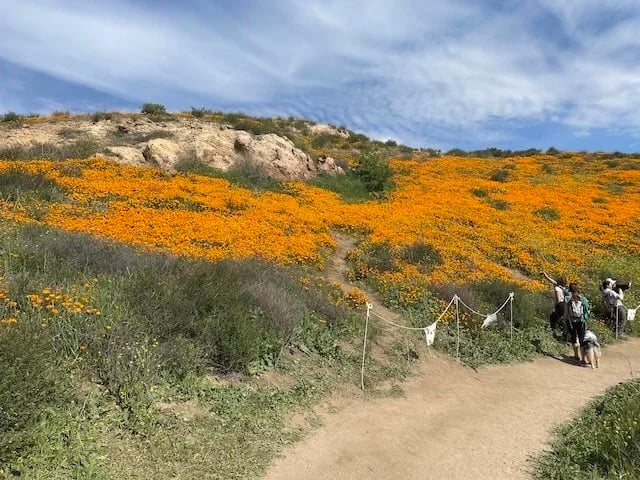
The trail winds through Weir Canyon Wilderness Park, which was incorporated into Santiago Oaks Regional Park in 2008. During late winter and early spring, the hillsides explode with California poppies, lupine, and other wildflowers that draw photographers from across the region.
What makes it special:
- Panoramic views of Orange County and the San Gabriel Mountains from the summit
- Outstanding wildflower displays from February through April
- Well-marked trail with multiple loop options
- Popular with hikers, trail runners, and mountain bikers
Details
Feature | Information |
|---|---|
Trail Distance | 3.7 miles (loop) |
Elevation Gain | 574 feet |
Difficulty | Moderate |
Time | 1.5 - 2 hours |
Parking | Street parking on Hidden Canyon Road |
Dogs | Permitted on leash |
Rating | 4.7 stars (4,400+ reviews on AllTrails) |
Local tip: Hike clockwise to tackle the steepest climb first while you're fresh. The descent on the back half is more gradual. Bring plenty of water, as there's almost no shade on the trail.
Santiago Oaks Regional Park
Address: 2145 N. Windes Drive, Orange, CA 92869
Santiago Oaks Regional Park is a 1,269-acre nature lover's paradise just minutes from Anaheim Hills. The park sits along Santiago Creek and offers everything from easy creekside strolls to challenging ridge climbs with sweeping views of northern Orange County.
The park's trail system connects directly to the Anaheim Hills Trail network and Weir Canyon, creating endless possibilities for exploration. A historic dam from 1892 and remnants of a Valencia orange grove planted in 1937 add historical interest to your hike.
What makes it special:
- 29 interconnecting trails for hikers, bikers, and equestrians
- Santiago Creek with seasonal water crossings
- Nature center with exhibits on local natural history
- Access to the broader 3,550-acre protected open space network
Trail highlights:
- Santiago Creek Trail: Easy, shaded creekside walk
- Barham Ridge Trail: Challenging climb with panoramic county views
- Historic Dam Trail: Easy walk to the 1892 dam (hikers only)
- Robbers Peak: Moderate climb with 360-degree views
Details
Feature | Information |
|---|---|
Park Size | 1,269 acres |
Hours | 7 AM to sunset, year-round |
Parking | $3 weekdays, $5 weekends |
Dogs | Permitted on leash |
Closure Note | Trails may close up to 3 days after rain |
Best Season | February - April (green hills, wildflowers) |
Local tip: Park at the main entrance on Windes Drive or access trails for free from Anaheim Hills Elementary School parking lot (after school hours or weekends).
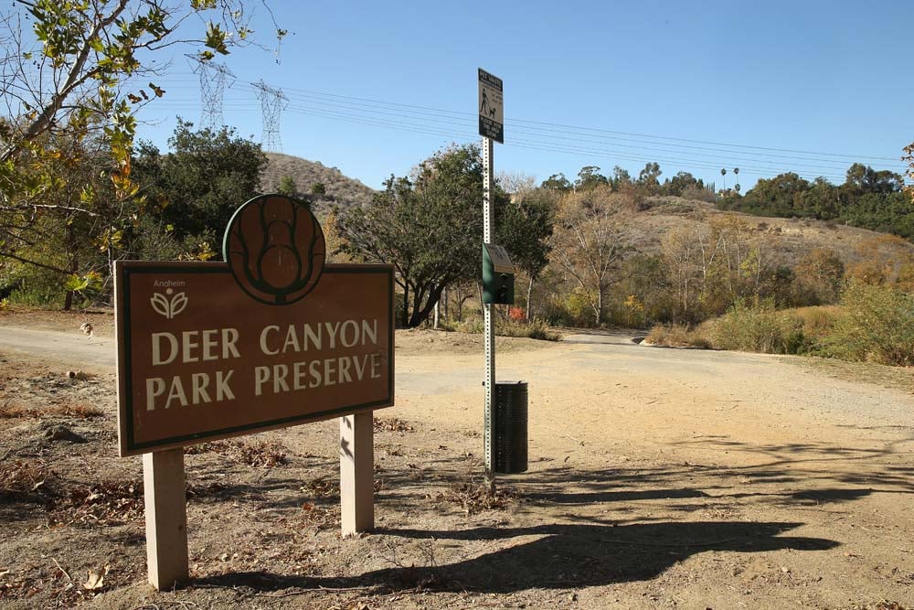
Deer Canyon Park Preserve
Address: 7502 E Hollow Oak Road, Anaheim, CA 92808
Deer Canyon Park Preserve is a hidden gem that most Anaheim Hills residents drive past without knowing it exists. This 103-acre wilderness area offers a quieter, less crowded hiking experience with trails winding through established oak trees and seasonal creek beds.
The preserve connects to Oak Canyon Nature Center and the Four Corners Trail, making it possible to link multiple parks into a longer adventure.
What makes it special:
- Peaceful atmosphere with far fewer visitors than Weir Canyon
- Beautiful oak trees and seasonal wildflowers
- Direct trail connections to Oak Canyon Nature Center
- Open to both hiking and horseback riding
Details
Feature | Information |
|---|---|
Park Size | 103 acres |
Trail Distance | 2.8 miles within the park |
Elevation Gain | 1,131 feet (full out-and-back) |
Difficulty | Moderate |
Parking | Street parking on Hollow Oak Road (limited) |
Dogs | Permitted on leash |
Best For | Solitude seekers, intermediate hikers |
Local tip: The trailhead can be tricky to find. Look for the preserve entrance near the intersection of Canyon Mist Lane and Creekview Lane.
Yorba Regional Park
Address: 7600 E La Palma Ave, Anaheim, CA 92807
Yorba Regional Park offers a different kind of outdoor experience. This 140-acre linear park stretches over a mile along the mouth of Santa Ana Canyon, providing flat, easy trails perfect for families, casual walkers, and anyone who wants to enjoy nature without a serious workout.
The park connects directly to the Santa Ana River Trail, giving residents access to a 30-mile paved pathway that runs all the way to the Pacific Ocean at Huntington Beach.
What makes it special:
- Four lakes with fishing, model boats, and kayak/paddleboat rentals
- 400+ picnic tables and 200 BBQ grills
- Six playgrounds for kids of all ages
- Direct access to Santa Ana River Trail
Details
Feature | Information |
|---|---|
Park Size | 140 acres |
Trail Distance | 1.4-mile loop within park, plus Santa Ana River Trail access |
Difficulty | Easy |
Hours | 7 AM - 9 PM (spring/summer), 7 AM - 6 PM (fall/winter) |
Parking | $3 weekdays, $5 weekends |
Dogs | Permitted on leash |
Bike Rentals | Available through Wheel Fun Rentals |
Local tip: This is the perfect starting point for biking the Santa Ana River Trail. Rent a bike at the park and ride the flat, paved path toward the coast. It's roughly 20 miles to Huntington Beach.
Santa Ana River Trail
Access Points: Yorba Regional Park, Featherly Regional Park, Green River Road
The Santa Ana River Trail is a crown jewel of Orange County's outdoor infrastructure. This 30-mile paved pathway runs from the Orange/Riverside County line all the way to the Pacific Ocean at Huntington Beach, passing through Anaheim Hills along the way.
For Anaheim Hills residents, it's essentially a 30-mile bike lane to the beach.
What makes it special:
- 12-foot-wide paved path suitable for biking, running, and walking
- Connects multiple regional parks and cities
- Grade-separated crossings minimize street interactions
- Access to Yorba Regional Park, Talbert Regional Park, and Huntington Beach Bike Trail
Details
Feature | Information |
|---|---|
Trail Length | 30 miles (Orange County section) |
Surface | Paved (asphalt) |
Difficulty | Easy |
Best For | Cycling, running, long-distance walking |
Dogs | Permitted on leash |
Equestrian | Separate dirt trail runs parallel |
Local tip: The trail can get hot with little shade. Start early on summer days and bring plenty of water. For a scenic afternoon, bike from Yorba Regional Park toward Angel Stadium and back.
Ronald Reagan Park
Address: 945 S Weir Canyon Road, Anaheim, CA 92808
Ronald Reagan Park (formerly Toyon Park) is an 18-acre hilltop park that serves as a convenient trailhead for the East Hills trail system while also offering standard park amenities for families.
The park sits on a plateau overlooking a wild area with horse trails and a creek, making it an easy starting point for both casual strolls and longer hikes into the Weir Canyon trail network.
What makes it special:
- Direct access to the 1.5-mile East Hills trail
- Large playground with zip track, swings, and climbing structures
- Covered picnic shelters with BBQ grills
- Sports facilities including basketball courts, baseball diamonds, and volleyball courts
Details
Feature | Information |
|---|---|
Park Size | 18 acres |
Trail Access | East Hills Trail (1.5 miles), connects to Weir Canyon |
Parking | 236 spaces, including horse trailer parking |
Amenities | Restrooms, picnic areas, playground, sports courts |
Dogs | Permitted on leash |
Best For | Families, trail access, sports |
Local tip: This is one of the best trailheads for accessing the Weir Canyon trail system with ample free parking. The 7.1-mile loop from Ronald Reagan Park to Weir Canyon and back offers a solid workout with beautiful canyon views.
Anaheim Hills Golf Course
Address: 6501 E Nohl Ranch Road, Anaheim, CA 92807
While not a hiking destination per se, Anaheim Hills Golf Course deserves mention for homeowners who appreciate the outdoor lifestyle. The hilltop course offers stunning views of the surrounding hills and canyons from the clubhouse and fairways.
Even non-golfers can enjoy the scenery and cuisine at the Scorecard Grille (now called Gallery), the on-site restaurant overlooking the course.
What makes it special:
- Panoramic views of Anaheim Hills from the elevated clubhouse
- Spanish Mediterranean-style architecture
- Restaurant and bar open to the public
- Event space for private gatherings with outdoor views

Trail Safety Tips
Before heading out, keep these local tips in mind:
Wildlife awareness: Rattlesnakes are common on Anaheim Hills trails, especially during warmer months. Watch where you step and keep dogs on leash. Coyotes are also present, so keep small pets close.
Sun protection: Most trails have limited shade. Bring a hat, sunscreen, and plenty of water. Start early on hot days.
Seasonal closures: Many trails in Santiago Oaks and Weir Canyon close for up to three days after rain to protect the trail surface. Check OC Parks for current conditions.
Wildflower season: Late February through April brings spectacular wildflower blooms to Weir Canyon and Santiago Oaks. Time your visit for the best displays.
Trail etiquette: Many trails are shared with mountain bikers and equestrians. Stay alert, yield to horses, and give bikers a heads-up when you hear them approaching.
Why Outdoor Access Matters for Homeowners
For homebuyers considering Anaheim Hills, access to outdoor recreation is one of the community's biggest selling points. Studies consistently show that proximity to parks and trails increases property values and homeowner satisfaction.
Anaheim Hills delivers on this front with thousands of acres of protected open space, a connected trail network, and a community culture that values the outdoor lifestyle. Whether you're a serious hiker, a casual walker, or simply someone who appreciates having nature nearby, Anaheim Hills offers an outdoor experience that's hard to match in Orange County.
If you're interested in finding a home with easy access to these trails and outdoor spaces, I'd be happy to show you the neighborhoods that offer the best options for your lifestyle.
Brian Kidd REALTOR® | CA DRE# 01901810 Canyon Realty www.canyonrealty.com
With over 20 years of experience in Orange County real estate, I help buyers and sellers navigate the Anaheim Hills, Yorba Linda, and surrounding markets. My local expertise ensures you find not just a house, but a home in a community that fits your lifestyle.
Frequently Asked Questions
What is the best hiking trail in Anaheim Hills?
Weir Canyon Trail is the most popular hiking trail in Anaheim Hills, featuring a 3.7-mile loop with 574 feet of elevation gain and panoramic views of Orange County. It holds a 4.7-star rating from over 4,400 reviews on AllTrails.
How many miles of hiking trails are in Anaheim Hills?
Anaheim Hills and the surrounding area offer access to over 50 miles of hiking trails when you include Oak Canyon Nature Center (4 miles), Weir Canyon (3.7 miles), Santiago Oaks Regional Park (29 trails spanning over 15 miles), Deer Canyon Preserve (2.8 miles), and connections to the 30-mile Santa Ana River Trail.
Are dogs allowed on Anaheim Hills hiking trails?
Most Anaheim Hills trails permit dogs on leash, including Weir Canyon Trail, Santiago Oaks Regional Park, Deer Canyon Preserve, Yorba Regional Park, and the Santa Ana River Trail. The exception is Oak Canyon Nature Center, which does not permit dogs (only service animals).
When is the best time to hike in Anaheim Hills?
The best hiking season in Anaheim Hills is late February through April, when temperatures are mild and hillsides are covered with California poppies and other wildflowers. Summer mornings before 9 AM are also good, as most trails have little shade.
Is there free parking at Anaheim Hills trails?
Oak Canyon Nature Center offers free parking. Weir Canyon Trail has free street parking on Hidden Canyon Road. Santiago Oaks Regional Park charges $3 weekdays and $5 weekends, but you can park free at Anaheim Hills Elementary School after school hours or on weekends. Yorba Regional Park also charges $3-$5.
How do I access the Santa Ana River Trail from Anaheim Hills?
The easiest access point is Yorba Regional Park at 7600 E La Palma Ave. From there, you can bike or walk the paved 30-mile trail all the way to Huntington Beach. The trail connects multiple regional parks along the way.
Are Anaheim Hills trails open after rain?
Trails in Santiago Oaks Regional Park and Weir Canyon may close for up to three days after rain to protect the trail surface. Check OC Parks (ocparks.com) for current conditions before heading out.
What wildlife might I see on Anaheim Hills trails?
Common wildlife includes rattlesnakes, coyotes, ground squirrels, cottontail rabbits, red-tailed hawks, scrub jays, and various lizard species. During spring, tarantulas are occasionally spotted on Weir Canyon trails.
Is Oak Canyon Nature Center good for kids?
Yes. Oak Canyon Nature Center is ideal for families with children due to its easy trails, year-round stream with small bridges and waterfalls, and the John J. Collier Interpretive Center featuring live animals and natural history exhibits. It's free to visit.
What is the elevation gain on Weir Canyon Trail?
Weir Canyon Trail has an elevation gain of 574 feet over 3.7 miles. The Weir Canyon and Anaheim Hills Trails Loop offers a longer 8.4-mile option with 1,558 feet of elevation gain for hikers seeking a more challenging workout.
Sources
Official Park Resources:
- City of Anaheim - Oak Canyon Nature Center: https://www.anaheim.net/1096/Oak-Canyon-Nature-Center
- City of Anaheim - Deer Canyon Park Preserve: https://www.anaheim.net/facilities/facility/details/Deer-Canyon-Park-Preserve-91
- City of Anaheim - Ronald Reagan Park: https://www.anaheim.net/facilities/facility/details/ronald-reagan-park-40
- OC Parks - Santiago Oaks Regional Park: https://www.ocparks.com/santiagooaks
- OC Parks - Yorba Regional Park: https://www.ocparks.com/yorbapark
Trail Information:
- AllTrails - Weir Canyon Trail: https://www.alltrails.com/trail/us/california/weir-canyon-trail
- AllTrails - Anaheim Trails: https://www.alltrails.com/us/california/anaheim
- AllTrails - Santiago Oaks Regional Park: https://www.alltrails.com/parks/us/california/santiago-oaks-regional-park
- TrailLink - Santa Ana River Trail: https://www.traillink.com/trail/santa-ana-river-trail/
Regional Trail Systems:
- Santa Ana River Trail - Wikipedia: https://en.wikipedia.org/wiki/Santa_Ana_River_Trail
- OC Parks - Santa Ana River Trail Map: https://www.ocparks.com/sites/ocparks/files/2021-04/Santa%20Ana%20River%20Trail%20Map.pdf
Recreation & Tourism:
- Visit Anaheim - Hiking and Trails: https://www.visitanaheim.org/things-to-do/outdoors-and-recreation/hiking-and-trails/